This alignment mainly consists of tiny stones protruding through the turf (Scale 1m).
A single stone row measuring 133m long, including at least 30 mainly small with some medium-sized stones situated on both sides of a ridge. The row is orientated ENE to WSW and has a sea view reveal and visual links to the landscape. There is a cairn at the upper (WSW) end. The row stands near three other rows, several cairns, prehistoric settlement, fields and reaves.
Location
| England Devon Dartmoor SX 55671 70601 Lat 50.51735 Long -4.0369586 |
Map showing the location of Sharpitor, North West 2 stone row.

Plan of the Sharpitor NW stone alignments (Source: 1:500 survey by Sandy Gerrard).
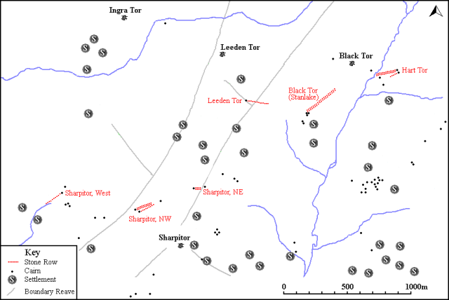
Map showing the position of Sharpitor NW2, other stone rows and sites.
Characteristics
| Type: Single | Length: 133m |
| No. of stones: 30 | Size of stones: Small and medium |
| Orientation: 57° | Altitude: 370m |
| Upper end: Cairn | Lower end: – |
| Straight (Yes or No) : No | Sea View: Yes |
| Context: Stone alignment and cairn | |
| Notes: | |
Other Information
| Public Access: Yes |
| Land Status: National Park |
| Scheduled Ancient Monument: Yes |
Identification
Category: Plausible. Despite the mangled state of this row no doubts have been expressed regarding its prehistoric interpretation.
Typology
This stone row is of Type S10. Information on this form of stone row and other rows of this type is available here.
Photographs

The single row at Sharpitor NW like its neighbour is very fragmentary in character. Perhaps the surprising thing is that they survive at all given their proximity to the road. View from above and east (Scale 1m).

Looking south west along the row (Scale 1m).

Stones forming part of Sharpitor NW 2 in the foreground and blocking stone of Sharpitor NW 1 beyond. View from north east (Scale 1m).

Possible cairn at the end of the row. It has been robbed and mutilated by tracks leading across the area making positive identification difficult. View from north east (Scale 1m).
Access Information
This is a very accessible stone row. Car parking is available very close to the row at SX 55678 70644.
Nearest Neighbour

Sharpitor NW 1 (3m)
Nearby Rows

Sharpitor, NE (382m)

Sharpitor, West (642m)

Leeden Tor (1.1km)

Black Tor, Stanlake (1.4km)

Hart Tor, South (2.2km)

Hart Tor, North (2.2km)
Online Resources
Megalithic Portal Modern Antiquarian PastScape Historic Environment Record
Prehistoric Monuments of Dartmoor Prehistoric Dartmoor Walks Prehistoric Dartmoor Walks Sea Views
Other References
Burl, A., 1993, From Carnac to Callanish – The prehistoric rows and avenues of Britain, Ireland and Brittany, Yale University Press, New York and London, pg. 215.
Butler, J., 1994, Dartmoor Atlas of Antiquities – Vol. 3 – The South-West, Devon Books Exeter, pgs. 44-46.
Timeline
VISITED:- 29th April 2013, 13th May 2015 and 30th July 2020
FIRST PUBLISHED:- 24th January 2016
LAST UPDATED:- 22nd November 2020


