Kerbed cairn in foreground and stone row beyond (Scale 1m).
A fine double stone row measuring 126m long, including at least 88 mainly medium-sized stones together with some small-sized stones situated on a west facing slope with restricted views that include a glimpse of the sea. The row is orientated ENE to WSW and leads downslope from a kerbed cairn at the ENE end. The WSW end has probably been truncated by tin streamworking. There is a second stone row, several cairns, a reave and prehistoric settlements in the vicinity.
Location
| England Devon Dartmoor SX 57708 71708 Lat 50.527798 Long -4.0088987 |
Map showing the location of Hart Tor, North stone row.

Simplified plan of the Hart Tor stone alignments. Hart Tor North shown in black.
(Source: survey by Sandy and Helen Gerrard)
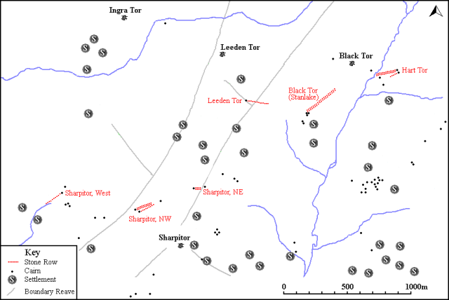
Map showing the position of Hart Tor North, other stone rows and sites.
Characteristics
| Type: Double | Length: 126m |
| No. of stones: 88 | Size of stones: Small and medium |
| Orientation: 76° | Altitude: 344m |
| Upper end: Cairn | Lower end: Pillar? |
| Straight (Yes or No) : No | Sea View: Yes |
| Context: Stone alignment, cairns and reave | |
| Notes: | |
Other Information
| Public Access: Yes |
| Land Status: National Park |
| Scheduled Ancient Monument: Yes |
Identification
Category: Plausible. No doubts have been expressed regarding the prehistoric interpretation of this row.
Typology
This stone row is of Type D10. Information on this form of stone row and other rows of this type is available here.
Photographs

The Hart Tor stones rows viewed from the slopes of nearby Black Tor.

A double row of stones ascending the hill towards the cairn. View from the north west (26 March 2013).

The double row approaching the kerbed cairn. View from west.

Looking downslope along the row from the kerbed cairn. View from the east.

Kerbed cairn at the top of the row. View from the west (20 October 2014).

Stone row leading away from the kerbed cairn. View from the east.
Access Information
Roadside car parking is available at SX 56985 71765. From here the row can be reached across open moorland. The row is situated about 600m to the east. The River Meavy needs to be crossed and it is usually possible to do this via a very narrow “footbridge”.
Online Resources
Megalithic Portal Modern Antiquarian PastScape Historic Environment Record
Prehistoric Monuments of Dartmoor Prehistoric Dartmoor Walks Sea Views
Other References
Burl, A., 1993, From Carnac to Callanish – The prehistoric rows and avenues of Britain, Ireland and Brittany, Yale University Press, New York and London, pg. 215.
Butler, J., 1994, Dartmoor Atlas of Antiquities – Vol. 3 – The South-West, Devon Books Exeter, pgs. 58-60.
Timeline
VISITED:- 23rd March 2013, 26th March 2013 and 20th October 2014
FIRST PUBLISHED:- 24th January 2016
LAST UPDATED:- 22nd November 2020


