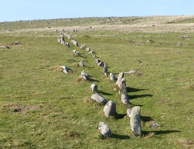
Trowlesworthy 1 double stone row on Dartmoor (England).
Welcome to this resource about the prehistoric stone rows of Great Britain.
In January 2012 a previously unrecorded alignment of stones was identified on the southern slope of Bancbryn, Carmarthenshire. Subsequent research has indicated that this stone row shares many characteristics with examples in South West England, but one particular aspect – a specific and pronounced visual link to the sea and a coastal headland – apparently had no English parallels. Preliminary research has revealed that this is not the case and that many of the Dartmoor rows have been specifically positioned and orientated taking often precise cognisance of the local topography to create tangible visual links with the sea.
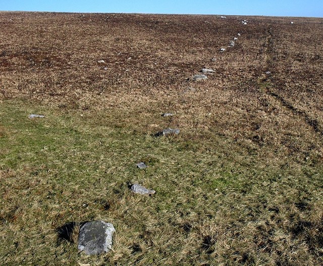
Bancbryn stone row in Carmarthenshire (Wales).
Following the publication of a series of articles discussing this phenomenon on the Heritage Journal blog between 2012 and 2016, which suggested a common ‘landscape treat’ identified on many stone rows on Dartmoor and elsewhere, it was decided to create this web site as a permanent focused home for the work being carried out by Dr Sandy Gerrard. He continues to investigate and document these alignments and over time is working to build a compelling body of evidence to support the hypothesis that many stone alignments represent special way-marked routes which were designed to provide the “traveller” with extraordinary visual treats. In turn it is hoped that this discovery may provide fresh insights into the character of Late Neolithic and Early Bronze Age society.
The Gazetteer has been created using a variety of sources. Sometimes the information is contradictory, not readily available or plain inaccurate. Wherever possible judgement has been used to provide the most accurate information but mistakes inevitably occur. Differences of fact, opinion and interpretation abound within the literature and this gazetteer can therefore only reflect current understanding. This means that it will be updated as fresh information is uncovered and over time with the help of its users it is hoped a really useful resource can be created. Enhancements will be carried out on a regular basis. New discoveries will be added and sites removed if the evidence justifies this action and therefore over time this resource should become increasingly useful. Constructive comments are always welcome and where these results in changes the contributor will always be gratefully acknowledged. Together we should be able to create a useful resource for all those interested in stone alignments. Please free to get in touch using the contact button.
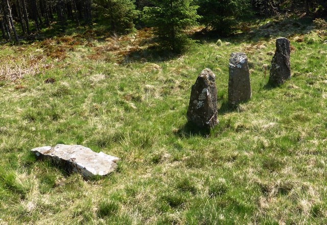
Maol Mor on the Isle of Mull (Scotland)
As well as the Gazetteer an Index Page has been created which brings all the plausible, probable and possible rows together on one page. This Index is the easiest way to browse through all the sites and access to all the Gazetteer entries is available at the click of a mouse. The stone rows in the Index Page are arranged from north to south and provide an overview of the resource.
Details on how to get to the rows is available in the Gazetteer. This information should be treated as guidance only and certainly not as proving a right of way or any other rights. Visitors are recommended to purchase a detailed map of the area and use this to find the rows. Most rows benefit from public access, but some are on private land and permission to visit those rows should always be sought. Every effort has been made to ensure that the access information in the Gazetteer is as accurate as possible but things change and car parking areas in particular may be removed or moved. If unsure it is always best to ask locally.
A pocket guide to the individual stone rows for your phone is available here. This guide provides information on the location, a short description, a SAT NAV number to help you find somewhere to park and a link to the gazetteer.
As well as the Gazetteer this web site is intended to act as a focus for stone alignment research. Articles on different aspects will be published on a regular basis. These are intended to engender discussion and encourage further research. Articles on stone alignment studies are welcomed and if you would like to contribute the results of your own research please do not hesitate to contact us.
The research articles were as far as possible correct at the time of publication, but inevitably as research continues, sites are visited and fresh sources are uncovered they need to be updated. The last update was at the end of 2019 and the next revision is planned for the end of 2020. Apologies for the occasional contradiction that this process causes.
If you are interested in a quick look at the rows and the variety of what exists why not start by checking out the Photograph Gallery or the Slide Show.
Wherever possible links to other web sites are provided. When created all the links worked, however some organisations seem to regularly alter their links and therefore some may no longer work. Apologies for the frustration this causes but this is beyond our control.
The terms stone alignment and stone row seem to be largely interchangeable. Both terms refer to the same type of archaeology and both have been used without any particular intent throughout. This can be confusing but whilst there is no consensus on which term should be applied both remain equally valid. Personally I prefer the term stone row because stone alignment implies the stones are arranged in a straight line and this is rarely the case. A case could probably be made for labelling the short stone rows composed either entirely or mainly of large slabs as stone alignments whilst the others could remain as rows. The Ordnance Survey use “stone row” on their mapping but this may simply be to save space.
The map below as well as providing an overview of stone row distribution provides access to information on the rows. Another map showing the position of the stones within the different rows can be found at the bottom of this page.
Distribution of prehistoric stone alignments in England, Wales and Scotland. Click on top right symbol to open a larger version.
Map showing the location of individual stones in the rows. Click on the box at the top right to open a larger version. There is a lot of data in this map and it may therefore take longer than usual to open.
FIRST PUBLISHED:- 12th January 2016
LAST UPDATED:- 24th February 2021

It will be interesting to see what transpires
LikeLike
Great idea I will be keeping my eye open on the Cumbrian uplands
LikeLike
wonderful site
LikeLike
tired from traversing the mountains, pathless, I descended into a sheltered upland valley deserted by noise and ringed by peaks, a tongue of land stood proud with two streams athwart it. Near the confluence I rested. Not the first to do so, a circle of stones, of domestic dimensions resided there, and next to them bridging to a cairn amongst the tussocks, a row of stones. I spent the night mesmerised by the vivid star scape and accompaniment of the gurgling brooks, before moving on the next morn towards a journeys end many miles away.
LikeLike
Domnívám se s ohledem na datování (pozdní neolit, doba bronzová) , že jde o nějaké trasování vyznačující polohu starých rýžovišť cínu. Takové řady se vyskytují i v Bretani ale i v Portugalsku, Španělsku a Irsku alei v Čechách. Všude kde se dobývaly suroviny – cín.
LikeLike
Thank you for this feedback. I too am very interested in tin. There is a fair bit of literature regarding the relationship between prehistoric settlements and tin deposits but nothing on the tinworks and stone rows. Since stone rows are also found in greater numbers where no tin has been found tinworking can not be the only answer. Regarding routes in general, it is clear that many were probably erected adjacent to routes but which came first the rows or the routes.
LikeLike