Length of the alignment. View from the west (Scale 1m).
A single stone row measuring 132m long, including at least 54 mainly medium-sized stones together with some small and large stones situated on a south west facing slope. The row is orientated north east to south west, there is a cairn at the upper (NE) end and a tall pillar at the other. An usual feature is a stone set next to the row midway along its length. The row stands near three other rows, several cairns, prehistoric settlement and fields.
Location
| England Devon Dartmoor SX 55058 70748 Lat 50.518516 Long -4.0458937 |
Map showing the location of Sharpitor, West stone row

Simplified plan of the Sharpitor, West stone row. (Source: Butler, J., 1994, 45).
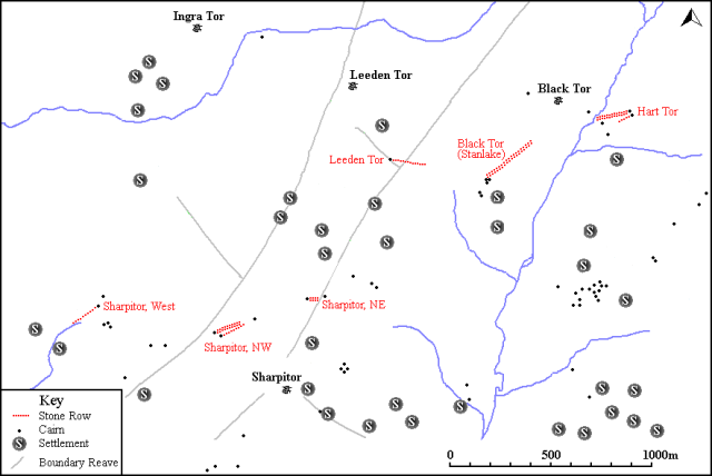
Map showing the position of Sharpitor West, other stone rows and sites.
Characteristics
| Type: Single | Length: 132m |
| No. of stones: 54 | Size of stones: Small, medium and large |
| Orientation: 50° | Altitude: 323m |
| Upper end: Cairn | Lower end: Pillar |
| Straight (Yes or No) : No | Sea View: Yes |
| Context: Cairns, prehistoric settlement and field system | |
| Notes: | |
Other Information
| Public Access: Yes |
| Land Status: National Park |
| Scheduled Ancient Monument: Yes |
Identification
Category: Plausible. Despite the mangled state of this row no doubts have been expressed regarding its prehistoric interpretation.
Typology
This stone row is of Type S12. Information on this form of stone row and other rows of this type is available here.
Photographs

The terminal pillar. View from west (23 April 2013).

A series of stones forming part of the lower length of the row. View from the south.

Small widely spaced stones. The undisturbed large stones next to the row demonstrates the row builders had chosen to ignore these much larger ones. This happens at a number of other rows and demonstrates that they were not always concerned with creating megalithic monuments. Small stones were clearly considered sufficient for the purpose even when larger ones were readily available.

A single stone set next to the row may indicate that this point on the row was particularly significant.

Looking north east along the row.

The cairn at the top of the row.
Access Information
Car parking is available at SX 55678 70644. From here walk due west for about 700m.
Online Resources
Megalithic Portal Megalithic Portal PastScape Historic Environment Record
Prehistoric Monuments of Dartmoor Prehistoric Dartmoor Walks Sea Views
Other References
Burl, A., 1993, From Carnac to Callanish – The prehistoric rows and avenues of Britain, Ireland and Brittany, Yale University Press, New York and London, pg. 215.
Butler, J., 1994, Dartmoor Atlas of Antiquities – Vol. 3 – The South-West, Devon Books Exeter, pgs. 43-44.
Timeline
VISITED:- 23rd April 2013
FIRST PUBLISHED:- 24th January 2016
LAST UPDATED:- 22nd November 2020


