Copyright: Tom Bullock. Original available at Megalithic Portal.
A probable double stone row measuring 13.4m long, including at least 17 small and medium-sized stones situated on a scarp on a south east facing slope. The row is orientated east to west and seems to extend into a cairn which itself has been modified by the construction of a shelter or sheiling. Double rows are unusual in Northern Scotland and the association of this one with a historic structure introduces an element of uncertainty. There are a number of cairns and prehistoric houses in the vicinity.
Location
| Scotland | Sutherland | Northern Scotland | NC 96570 19020 |
| Lat 58.14803338 Long -3.758837334 | |||
Map showing the location of Torrish Burn stone row.
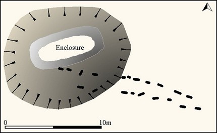
Simplified plan of the Torrish Burn stone alignment. From a survey by the Royal Commission available here and fieldwork.
Characteristics
| Type: Double | Length: 13.4m |
| No. of stones: 17 | Size of stones: Small and medium |
| Orientation: 90° | Altitude: 87m |
| Upper end: Cairn | Lower end: – |
| Straight (Yes or No) : No | Sea View: No |
| Context: Cairns and prehistoric settlement | |
| Notes: This stone alignment is very different in form and character to the other stone rows in Northern Britain. In particular, the stones are larger and form a double row rather than the usual multiple rows. In Wales, Cadw would see this as an obstacle to acceptance, but in reality this is a characteristic of many regions where isolated examples of types usually found elsewhere in Great Britain are recorded. | |
Other Information
| Public Access: Yes |
| Land Status: |
| Scheduled Ancient Monument: Yes |
Identification
Category: Probable. The enclosure built on top of the cairn may be of historic date and therefore it is possible that the stones were erected at the same time. However, no obvious historic function for the standing stones can be suggested and for this reason and despite the form of the row not being typical in this region a stone row explanation seems most likely.
Typology
This stone row is of Type D4. Information on this form of stone row and other rows of this type is available here.
Photographs

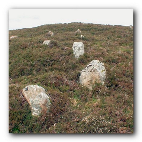
Looking ESE along the double row (Scale 1m).

Looking WNW and upslope along the alignment (Scale 1m). The largest stone is 0.5m high and several are taller then 0.3m.

Looking WNW from above (Scale 1m). The cairn at the top of the double row is clearly visible from this angle.

The alignment is on a relatively steep slope which is unusual for relatively short rows. View from north.

View from east showing the alignment, enclosure and probable cairn.

View from above and west of the alignment (Scale 1m). This double row is uncharacteristic of the rows in Northern Britain consisting as it does of relatively large stones arranged in a double row. Multiple rows of mainly small stones are the norm in this part of Great Britain.

Double row and enclosure. View from north west (Scale 1m). The enclosure is considered to be of historic date but it appears to have been inserted into an earlier mound which is very likely to be the remains of a cairn which is broadly contemporary with the alignment.

Double row leading upslope to a cairn. View from east (Scale 1m).

View from above and south (Scale 1m).

View from above and north (Scale 1m). The form of the enclosure and cairn are clearly discernible from this angle.
Access Information
Car parking is available at NC 96831 18754. From here walk about 380m to the north west across uneven open moorland.
Online Resources
Megalithic Portal Canmore Historic Environment Record Caithness Field Club Bulletin
Other References
Burl, A., 1993, From Carnac to Callanish – The prehistoric rows and avenues of Britain, Ireland and Brittany, Yale University Press, New York and London, pg. 224.
Timeline
VISITED:- 1st September 2016
FIRST PUBLISHED:- 13th February 2016
LAST UPDATED:- 2nd January 2018
