View from east.
A single stone row measuring 82m long, including at least 44 mainly medium-sized stones together with some small and large stones situated on a south west facing slope. The row is orientated east to west, there is a cairn at the upper eastern end and a tall pillar at the other. The row stands near another row, cairns and prehistoric settlements.
Location
| England Devon Dartmoor SX 57536 63978 Lat 50.458288 Long -4.0083797 |
Map showing the location of Trowlesworthy 2 stone row.

Simplified plan of Trowlesworthy 2 stone row. Green dots represent recumbent slabs.
(After Butler, J., 1994, 171).
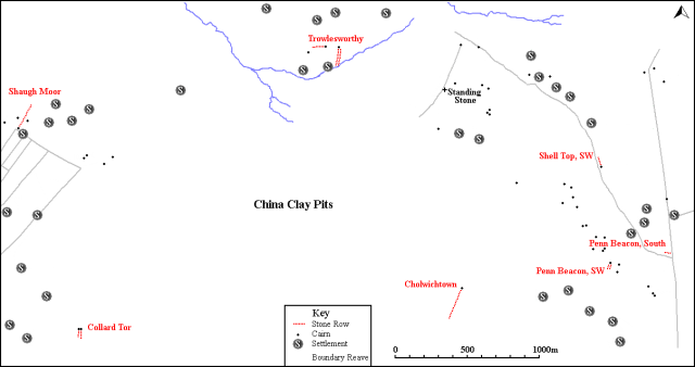
Map showing the position of Trowlesworthy 2, other stone rows and sites.
Characteristics
| Type: Single | Length: 82m |
| No. of stones: 44 | Size of stones: Small, medium and large |
| Orientation: 85° | Altitude: 282m |
| Upper end: Cairn | Lower end: Pillar |
| Straight (Yes or No) : No | Sea View: No |
| Context: Stone alignment, cairns and prehistoric settlement | |
| Notes: | |
Other Information
| Public Access: Yes |
| Land Status: National Park |
| Scheduled Ancient Monument: Yes |
Identification
Category: Plausible. No substantiated doubts have been expressed regarding the prehistoric interpretation of this row.
Typology
This stone row is of Type S12. Information on this form of stone row and other rows of this type is available here.
Photographs

Looking eastward along the row. The final stone is clearly off-set from the row (Scale 1m).
There is a marked curve in this row. The cairn at the top of Trowlesworthy 1 can be seen beyond the end of this row (Scale 1m).

Stone row passing a later pillow mound. View from north east.

The western length of the stone row. View from south east.

Looking westward along the row. It is clear that it is sinuous in form and there is one marked change in orientation.

The kerbed cairn at the top of the row. View from the south (Scale 1m).

View from above and east of the kerbed cairn in the foreground and row beyond.

Kerbed cairn at the upper end of the row. View from above and north (Scale 1m).

View from above and east of the stone row and historic rabbit farm pillow mound.

In common with all longer rows this alignment is far from straight. View from above and east.
Access Information
Car parking is available at SX 57055 63069. From here take the track leading north east which follows the northern edge of the Whitehill Yeo china clay pit. Follow this track to SX 57717 63693 then head north alongside the leat for about 280m at which point Trowlesworthy Row 1 will be reached. Trowlesworthy Row 2 is a short distance further on below the leat.
Online Resources
Megalithic Portal Modern Antiquarian PastScape Historic Environment Record
Prehistoric Monuments of Dartmoor Prehistoric Dartmoor Walks
Other References
Burl, A., 1993, From Carnac to Callanish – The prehistoric rows and avenues of Britain, Ireland and Brittany, Yale University Press, New York and London, pg. 215.
Butler, J., 1994, Dartmoor Atlas of Antiquities – Vol. 3 – The South-West, Devon Books Exeter, pgs. 171-172.
Timeline
VISITED:- 12th April 2013, 30th April 2013 and 16th May 2015
FIRST PUBLISHED:- 24th January 2016
LAST UPDATED:- 22nd November 2020


