
This sinuous stone alignment measures 351m long and includes a line of at least 174 stones leading eastward from a kerbed cairn at SX 58690 69273.
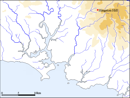
On high ground between the valleys of the Newleycombe Lake and Narrator Brook at SX 58690 69273 is the impressive Hingston Hill stone alignment. The alignment is far from straight and in common with many others on Dartmoor it has clearly defined, restricted and contrived views to the sea. At a single point along the alignment the sea disappears or appears depending on your direction of travel. This phenomenon is a recurring feature of many rows and very strongly supports the hypothesis that there is a direct visual relationship between the rows and the sea and that therefore the alignment builders were seeking at the very least to denote this. Many of the rows appear to have been specifically positioned and orientated to achieve this special form of inter-visibility and indeed in some instances the siting of the rows is so precise that if they had been positioned just a few metres from their present position or aligned a few degrees differently no sea views would be visible from them. At Hingston Hill if the alignment had been sited 20m north or south the tantalising sea view would not be visible. Even more interestingly if the row had been extended a few more metres further to the west the kerbed cairn at the end which currently lies within an area without sea views would have fallen within an area with a view to the sea.
The Hingston Hill alignment in common with many rows falls into two discrete areas – a length with views to the sea and a length with no such views. The eastern part of the alignment travels through an area from which a sea triangle is visible. Under certain lighting conditions this will appear as a small triangular white light until as you get to 80m from the western end it suddenly disappears. I can accept that if this happened at one or two sites this could be a coincidence, but this phenomenon is repeated time and time again as we shall see during the coming months. The evidence that many alignments were specifically built to denote the routes along which this happens is cumulatively compelling and I hope to present a convincing case to support an explanation for why many alignments are positioned where they are. Acceptance of this argument may in turn provide an insight into the character or perhaps the mind-set of those who built and used these monuments.
The computer generated images presented below were generated using the “ground level-view” available within Google Earth. Fieldwork elsewhere has confirmed that this is a reliable though not infallible tool.

View from the eastern end of the stone alignment with the sea triangle formed between Trowlesworthy on the left and Gutter Tor.

As one walks westward along the row the sea triangle remains visible after 100m.

After 200m the sea triangle retains its form. If the row had been placed a short distance to the north or south this view would not exist.

80m from the end of the row the sea triangle starts to rapidly vanish behind rising ground on Hingston Hill.

At the top of the row the view to the sea is blocked by the rising ground of Hingston Hill and the kerbed cairn is hidden from the sea.
Profile Analysis
An examination of cross-sectional profiles from the row to the sea allows the arc of inter-visibility to be plotted onto a map. The juxtaposition of the nearby hills block other views to the sea and thereby create the small clearly defined triangle of visible sea.

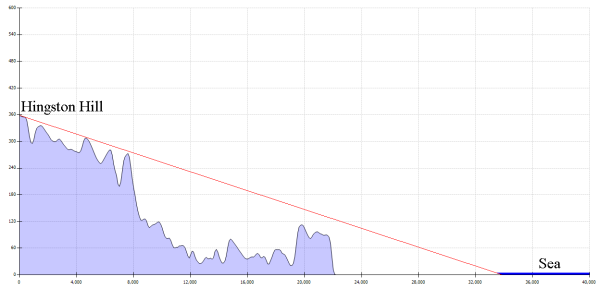
A cross-section along the centre of the arc illustrates the character of the topography within the arc of inter-visibility and shows why much of the land between the alignment and sea cannot be seen.
