
Stones in the foreground may form part of the stone rows identified by the Royal Commission. View from east (Scale 1m). The large stone on the skyline is the standing stone in the centre of the complex.
A probable fan-shaped multiple stone row measuring 8m long, including at least 8 small and medium-sized stones arranged in 4 separate lines situated at the eastern end of a terrace overlooking the Strath of Kildonan. The row is orientated north to south, has been damaged since it was first recorded and is associated with a number of small cairns which may be broadly contemporary. The row stands in an area with 3 other stone rows, a standing stone, stone circle and further cairns.
Location
| Scotland | Sutherland | Northern Scotland | NC 89281 23496 |
| Lat 58.18644708 Long -3.8847207 | |||
Map showing the location of Learable Hill, Row 3.
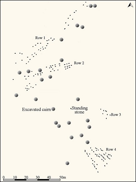
Plan of the Learable Hill stone alignments. (Source: Survey by Royal Commission). Original available here.
Characteristics
| Type: Multiple | Length: 8m |
| No. of stones: 8 | Size of stones: Small and medium |
| Orientation: 0° | Altitude: 161m |
| Upper end: – | Lower end: – |
| Straight (Yes or No) : No | Sea View: No |
| Context: Cairns, standing stone, stone alignments and stone circle | |
| Notes: 4 rows. This row is depicted on the survey by the Royal Commission, but is not shown on the plan on page 130 of Burl, 1993. There are at least three surviving stones at this location and others may be hidden in the heather. The tallest stone is 0.5m high. A distinctive hill at 289° disappears at the lower end of this alignment. | |
Other Information
| Public Access: Yes |
| Land Status: |
| Scheduled Ancient Monument: Yes |
Identification
Category: Probable. Burl does not depict these stones on his plan of Learable Hill, presumably because he does not consider them to form part of a stone row. Only some of the stones shown on the Royal Commission plan are currently visible. For these two reasons uncertainty regarding the identification of this row should be acknowledged.
Typology
This stone row is of Type M1. Information on this form of stone row and other rows of this type is available here.
Access Information
Car parking is available at NC 90042 23237. From here carefully cross the suspension bridge across the River Helmsdale. Follow the path to the railway crossing. Ensure there are no trains coming before crossing and make sure the gates are carefully closed. Follow the path up the hill to NC 89373 23682 and then walk south west for about 200m.
Online Resources
Megalithic Portal Modern Antiquarian Canmore Historic Environment Record
Other References
Burl, A., 1993, From Carnac to Callanish – The prehistoric rows and avenues of Britain, Ireland and Brittany, Yale University Press, New York and London, pgs. 130 and 224.
Timeline
VISITED:- 1st September 2016
FIRST PUBLISHED:- 13th February 2016
LAST UPDATED:- 2nd January 2018
