
View from above and west (Scale 1m).
A single stone row measuring 7.2m long, originally including 8 small and medium-sized stones situated on a south facing slope. The stones measure up to 0.52m high but most are much smaller, and four are recumbent. The row has been partially excavated although no report has been published. The row is orientated east to west and stands in an area with a broadly contemporary standing stone.
Location
| Wales | Powys | Mid Wales | SN 94921 60315 |
| Lat 52.23094479 Long -3.54001472 | |||
Map showing the location of Saith Maen WSW stone row.
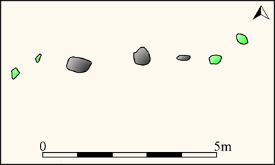
Plan of Saith Maen WSW stone row (Source: survey by Sandy Gerrard at 1:100). Recumbent stones are shown green.
Characteristics
| Type: Single | Length: 7.2m |
| No. of stones: 8 | Size of stones: Small and medium |
| Orientation: 80° | Altitude: 400m |
| Upper end: – | Lower end: – |
| Straight (Yes or No) : No | Sea View: No |
| Context: – | |
| Notes: Originally there were eight stones but since the row was first recorded the eastern stone has been removed. | |
Other Information
| Public Access: Yes |
| Land Status: |
| Scheduled Ancient Monument: BR065 |
Identification
Category: Plausible. No doubts have been expressed regarding the prehistoric identity of this row.
Typology
This stone row is of Type S1. Information on this form of stone row and other rows of this type is available here.
Photographs

The western end of the row. View from above and east (Scale 1m).

The western end of the row. View from above and east (Scale 1m).

View from north (Scale 1m).

Looking west along the row (Scale 1m).

The best preserved part. View from east (Scale 1m).

Looking west along the row (Scale 1m).
Individual Stones

Plan of Saith Maen WSW stone row showing the position of the numbered stones shown below.
Stone 1

Stone 1 measures 0.38m long by 0.28m wide, stands up to 0.14m high and is orientated at 10°. View from east (Scale 1m).
Stone 2

Stone 2 measures 0.29m long by 0.19m wide, stands up to 0.08m high and is orientated at 203°. View from east (Scale 1m).
Stone 3

Stone 3 sitting in an archaeological excavation trench, measures 0.62m long by 0.35m wide, stands up to 0.52m high and is orientated at 284°. View from south east (Scale 1m).
Stone 4

Stone 4 measures 0.42m long by 0.42m wide and stands up to 0.46m high. The stone on the left is number 3 and that on the right number 5. View from south (Scale 1m).
Stone 5

Stone 5 measures 0.46m long by 0.12m wide, stands up to 0.24m high and is orientated at 270°. View from south (Scale 1m).

Stone 5 in the foreground with stones 4 and 3 beyond. View from east (Scale 1m).
Stone 6

Stone 6 measures 0.40m long by 0.34m wide, stands up to 0.08m high and is orientated at 255°. View from east with stones 5 and 4 in background (Scale 1m).

View from south of Stones 5 and 6. The ranging rod is positioned beside Stone 6 (Scale 1m).
Stone 7

Stone 7 measures 0.38m long by 0.32m wide, stands up to 0.14m high and is orientated at 102°. View from north east with stones 3 – 6 beyond (Scale 1m).
Access Information
Limited parking is available at SN 94788 59199. Be careful not to block the adjacent farm entrance. From here walk north along the path to the row.
Online Resources
Megalithic Portal Modern Antiquarian Coflein Archwilio
Other References
Burl, A., 1993, From Carnac to Callanish – The prehistoric rows and avenues of Britain, Ireland and Brittany, Yale University Press, New York and London, pg. 225.
Timeline
VISITED:- 20th August 2018
FIRST PUBLISHED:- 12th February 2016
LAST UPDATED:- 9th March 2019
