
View from west (Scale 1m).
A possible single stone row measuring 4.8m long, including one medium and two large stones situated on level ground. The stones are orientated east to west and stand at the northern end of a long mound. Whilst they may represent a structural element of the long mound the possibility that this is a stone row cannot be wholly dismissed.
Location
| Wales | Powys | Mid Wales | SO 08999 54157 |
| Lat 52.178134 Long -3.3322723 | |||
Map showing the location of the Bryntwppa standing stones
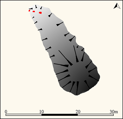
The standing stones (red) at Bryntwppa protrude from the northern end of a long mound (Source: survey from Google Earth and fieldwork).
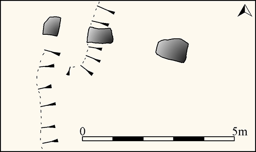
Plan of the stones at Bryntwppa (Source: survey by Sandy Gerrard at 1:100)
Characteristics
| Type: Single | Length: 4.8m |
| No. of stones: 3 | Size of stones: Medium and large |
| Orientation: 98° | Altitude: 216m |
| Upper end: – | Lower end: – |
| Straight (Yes or No) : | Sea View: No |
| Context: Long cairn | |
| Notes: | |
Other Information
| Public Access: No |
| Land Status: |
| Scheduled Ancient Monument: RD236 |
Identification
Category: Possible. To all intents and purposes this looks like a stone row, a conclusion strengthened by the stones being arranged in height order with the highest on the east and the lowest in the west. However, the stones appear to be situated in a long mound and may therefore represent the remains of a structure within a long cairn. The stones are also incorporated into an historic field boundary which further complicates the situation and makes a definitive interpretation without further evidence impossible. This uncertainty is reflected in the identification category.
Typology
This stone row is of Type S3. Information on this form of stone row and other rows of this type is available here.
Photographs

View from east showing the location of the stones at Bryntwppa.

View from south (Scale 1m).

View from north west (Scale 1m).

View from north west (Scale 1m).

View from south. The stones position within a broad mound is obvious.

View from above and south east. The edge of the mound is highlighted with white circles (Scale 1m).

View from east (Scale 1m).

View from above and south west (Scale 1m). There is a cluster of smaller rocks in the vicinity of the standing stones. These could be the result of historic field clearance or represent exposed cairn material.

View from above and north west. The edge of the mound is highlighted with white circles (Scale 1m).

View from north (Scale 1m). From this angle it is clear that the stones are within the mound. Without excavation it is not possible to know whether the stones were erected sat the same time as the mound and therefore form part of it, were earlier and therefore probably a stone row that was incorporated into a long cairn or added afterwards and therefore part of the historic land-use of this area.

View from south west (Scale 1m). The stone on the left measures up to 0.55m high, the middle one is up to 1.15m tall and whilst the one on the right is only 1m it is higher than the middle one because of its elevated position on the mound.

View of “long cairn” and stones from the south west (Scale 1m).

View of “long cairn” and stones from the north (Scale 1m).
Access Information
There is no public access to this site. Permission to visit should be sought at Bryntyppa Farm or the adjacent bungalow at SO 09051 54535.
Online Resources
Megalithic Portal Coflein Archwilio
Timeline
VISITED:- 21st August 2018
FIRST PUBLISHED:- 12th February 2016
LAST UPDATED:- 3rd February 2020
