View from the north (Scale 1m).
A single stone row measuring 179m long, including at least 71 mainly small-sized stones and a few medium stones situated on a north west facing slope with a dramatic sea view reveal. The row is orientated NNE to SSW, leads downslope from a kerbed cairn standing at the SSW end and stands just outside the terminal reave of a prehistoric coaxial field system. Nearby are two further cairns and several prehistoric settlements.
Location
| England Devon Dartmoor SX 55430 63443 Lat 50.452886 Long -4.0379215 |
Map showing the location of Shaugh Moor stone row.

Simplified plan of Shaugh Moor stone alignment (Source: Butler, J., 1994, 104).
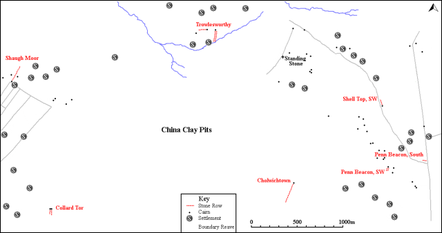
Map showing the position of Shaugh Moor, other stone rows and sites.
Characteristics
| Type: Single | Length: 179m |
| No. of stones: 71 | Size of stones: Small and medium |
| Orientation: 28° | Altitude: 258m |
| Upper end: Cairn | Lower end: Pillar |
| Straight (Yes or No) : No | Sea View: Yes |
| Context: Cairns, prehistoric settlements and field system | |
| Notes: | |
Other Information
| Public Access: Yes |
| Land Status: National Park |
| Scheduled Ancient Monument: Yes |
Identification
Category: Plausible. No doubts have been expressed regarding the prehistoric interpretation of this row.
Typology
This stone row is of Type S10. Information on this form of stone row and other rows of this type is available here.
Photographs

The upper (southern) length of the row. View from north (Scale 1m).

The row includes mainly small stones protruding only slightly above the turf. View from west (Scale 1m).

The row leads up the slope at an angle. View from north (Scale 1m).

The lower (northern) length is more distinct than the remainder. View from south (Scale 1m).

In common with all long rows the Shaugh Moor alignment is sinuous in form. View from north (Scale 1m).

View from above and north west of a short length of the row (Scale 1m).

Looking south along the row (Scale 1m).

View from above and north of the stone row (Scale 1m).
1st August 2020

The northern length of the row. View from the north east (Scale 1m).

View from the north (Scale 1m).

The southern length of the row. View from the north.

The visual relationship between the row and the sea is obvious. Most of the row is hidden from the sea by rising ground and it is only at the top that the sea comes into view. View from north (Scale 1m).

The sinuous form of the row is apparent.

The row approaching the southern end. View from north (Scale 1m).

The cairn at the top of the row. View from the south (Scale 1m).
Access Information
Road side car parking is available at SX 55337 63758. From here walk south up the hill until you are clear of the china clay dump on your left. Carefully cross the road and head south east across the open moorland for about 260m.
Online Resources
Megalithic Portal Megalithic Portal Modern Antiquarian PastScape
Historic Environment Record Prehistoric Monuments of Dartmoor Prehistoric Dartmoor Walks
Other References
Burl, A., 1993, From Carnac to Callanish – The prehistoric rows and avenues of Britain, Ireland and Brittany, Yale University Press, New York and London, pg. 215.
Butler, J., 1994, Dartmoor Atlas of Antiquities – Vol. 3 – The South-West, Devon Books Exeter, pgs. 105-106.
Timeline
VISITED:- 24th March 2013, 22nd October 2014 and 1st August 2020
FIRST PUBLISHED:- 24th January 2016
LAST UPDATED:- 22nd November 2020


