
View from north east (Scale 1m).
A probable triple or possibly multiple stone row measuring at least 27.71m long, including 21 small and medium-sized stones situated on an east facing slope. The row is orientated NNE to SSW and was partly excavated in 2011. Stone sockets were found but no dating evidence was recovered.
Location
| Wales Powys Brecon Beacons SO 05633 18064 Lat 51.853125 Long -3.371559 |
Map showing the location of Craig Y Fan Ddu stone row.
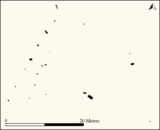
Plan of Craig y Fan Ddu stone row (Source: 1:200 survey by Sandy Gerrard).
Characteristics
| Type: Triple or perhaps multiple | Length: 27.71m |
| No. of stones: 21 | Size of stones: Small and medium |
| Orientation: 25° | Altitude: 500m |
| Upper end: – | Lower end: – |
| Straight (Yes or No) : | Sea View: No |
| Context: | |
| Notes: Excavated | |
Other Information
| Public Access: Yes |
| Land Status: National Park |
| Scheduled Ancient Monument: No |
Identification
Category: Probable. This site looks like an Exmoor type row. The only elements of uncertainty concern its position on a relatively steep slope and the plan form which is far from clear. The site may be interepreted as a triple row with a few outliers or a multiple row perhaps originally including up to 7 rows. The surviving evidence best fits a prehistoric stone row identification but a small element of doubt remains and should be acknowledged.
Typology
This stone row is of Type T10. Information on this form of stone row and other rows of this type is available here.
Photographs

Copyright: Martyn Copcutt. Original available at Megalithic Portal.

View from west showing the location of the stone row. There was plenty of suitable stone readily available.

The stone row view from the south west.

The southern part of the stone row. View from the north east (Scale 1m).

The southern part of the stone row. View from the east (Scale 1m).

A short length of drystone walling to the north east of the rows at SO 05677 18084 has previously been interpreted as a possible peat stack. There is however no peat cutting in the vicinity. It is possible that it was in some way associated the stone rows and this would suggest an historic date for the stone rows. However, until a more plausible explanation is available it is more likely that they represent the remains of a stone row.
Individual Stones

Plan of the Craig y Fan Ddu stone row showing the numbered stones.

Stone 1 measures 0.26m long by 0.20m wide, stands up to 0.62m high and is orientated at 22°. View from south west (Scale 1m).

Stone 2 measures 0.29m long by 0.14m wide, stands up to 0.46m high and is orientated at 17°. View from north east (Scale 1m). Stone 1 in the background.

Stone 3 measures 0.15m long by 0.15m wide, stands up to 0.50m high and is orientated at 12°. View from north east (Scale 1m). Stones 1 and 2 in the background.

Stone 4 is recumbent, measures 0.69m long by 0.45m wide, stands up to 0.12m above the ground surface and is orientated at 94°. View from north east (Scale 1m). Stone 3 in the background.

Stone 5 measures 0.43m long by 0.30m wide, stands up to 0.35m high, is leaning to the east and is orientated at 22°. The stone would have originally stood about 0.45m high. View from north east (Scale 1m). Stones 1 – 4 in the background.

Stone 5 viewed from south. Stone 6 in the background (Scale 1m).

Stone 6 is recumbent, measures 1.18m long by 0.44m wide, stands up to 0.11m above the ground surface and is orientated at 150°. View from south (Scale 1m).

Stone 6 viewed from the north (Scale 1m). Other stones forming part of the rows in the background.

Stone 7 is recumbent, measures 0.60m long by 0.08m wide, stands up to 0.08m above the ground surface and is orientated at 134°. View from north (Scale 1m).

Stone 8 is recumbent, measures 1.10m long by 0.13m wide, stands up to 0.05m above the ground surface and is orientated at 21°. View from north (Scale 1m).

Stone 9 measures 0.28m long by 0.09m wide, stands up to 0.70m high, is leaning to east and is orientated at 44°. The stone would originally have stood about 0.77m high. View from north west (Scale 1m).

Stone 10 measures 0.20m long by 0.08m wide, stands up to 0.50m high and is orientated at 30°. View from south east (scale 1m).

Stone 10 viewed from south (Scale 1m).

Stone 11 measures 0.29m long by 0.16m wide, stands up to 0.32m high and is orientated at 110°. View from south east (Scale 1m).

Stone 12 measures 0.34m long by 0.16m wide, stands up to 0.28m high and is orientated at 25°. View from north east (Scale 1m).

Stone 13 is recumbent, measures 0.43m long by 0.15m wide, stands up to 0.20m above the ground surface and is orientated at 82°. The stone is largely covered by vegetation. View from south (Scale 1m).

Stone 14 is recumbent, measures 0.47m long by 0.26m wide, stands up to 0.26m above the ground surface and is orientated at 54°. The stone is partly covered by vegetation. View from south east (Scale 1m).

Stone 15 measures 0.12m long by 0.10m wide, stands up to 0.46m high and is orientated at 49°. View from south west (Scale 1m).

Stone 16 measures 0.16m long by 0.14m wide, stands up to 0.30m high and is orientated at 126°. View from east (Scale 1m).

Stone 17 measures 0.30m long by 0.11m wide, stands up to 0.50m high and is orientated at 50°. View from east (Scale 1m).

Stone 18 (foreground) is recumbent, measures 0.74m long by 0.42m wide, stands up to 0.37m above the ground surface and is orientated at 76°. View from south with Stone 17 beyond beside ranging rod (Scale 1m).

Stone 19 measures 0.20m long by 0.16m wide, stands up to 0.54m high and is orientated at 45°. View from south east (Scale 1m).

Stone 20 is recumbent, measures 0.80m long by 0.27m wide, stands up to 0.10m above the ground surface and is orientated at 102°. View from east (Scale 1m).

Stone 21 is recumbent, measures 1.30m long by 0.64m wide, stands up to 0.14m above the ground surface and is orientated at 128°. View from south east with Stone 20 beyond (Scale 1m).
Access Information
Plenty of car parking is available at SO 05653 17599. From here follow the steep footpath north to SO 05444 17948 then head north east for a short distance to the row.
Online Resources
Megalithic Portal Coflein Archwilio Excavation Report
Timeline
VISITED:- 4th September 2018
FIRST PUBLISHED:- 27th January 2016
LAST UPDATED:- 10th October 2018
